en

Experience adventure on the hiking trails in the Štiavnica Hills near Hotel Salamandra. Explore the charm of the beautiful countryside and try the hiking trips around Banská Štiavnica.
What awaits you?
The oldest inhabited areas of Banská Štiavnica, mining history, and natural beauty. The Old Town Trail leads you to the ruins of the castle and settlement of Bana on Glanzenberg Hill, the site of the oldest known opencast mining in the Štiavnica Hills. Along the trail are shelters with seating, interesting views and the remains of historic stone buildings. From the side of the town centre, the Old Town Trail starts on Úvozná Street, turns left after the peasant settlement and crosses onto a plateau with former quarrying sites. At the end of the plateau, it rises to the level of an earth mound and continues along the ridge of the hill to its summit with the ruins of the castle and a beautiful 360° view. The route then descends to the Veľká Vodárenská Taich and, from there, climbs to the Červená studňa saddle.
What awaits you?
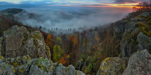
Discover the natural values of the Sitno National Nature Reserve and the history of the settlement of Sitno. The trail starts at Tatarska meadow and is a partial variant of the green-marked trail from Lake Počúvadli. During the 13 information stops, you learn about the natural and cultural-historical attractions of Sitno and surroundings. While walking along the nature trail, you may be interested in the so-called Rock Town. It consists of 50-metre-high cliffs formed by the disintegration of a lava flow as it passes through gravitational fissures. They are shaped like bastions, needles or towers.
What awaits you?
The history of mining activity and natural values in the central part of the Protected Landscape Area. On the walk, you discover the remains of the oldest mining activity in the area, and on the way, you also visit the Ottergrund reservoir, the highest point in the area. The route is lined with 16 information boards that introduce you to mining activity and its impact on the landscape, with the starting point of this hiking trail being the Červená studňa saddle. Wandering along the Terézia vein is not difficult. The route is easy to follow and can be completed by children and older people in 2-3 hours.
The central motif of the nature trail is mining activity and its impact on the landscape. However, the area is also of great botanical value, a source of interest. Wandering along the Theresia vein, you can admire the mixture of thermophilous and mountain species and the planting of new species of trees in areas where the original forests have been decimated by intensive mining for the needs of the mines.
If you are lucky, during your wanderings through the region, you might spot the rare spotted salamander, which we have taken as our own at the hotel. You might also spot roe deer, which, in time, may stray into the outlying gardens of the town. The beauty of the nature trail is enhanced by the ubiquitous birdsong, which creates a pleasant soundscape.
What awaits you?
Natural and mining monuments, including the Banská Štiavnica water reservoirs. The trail is a partial continuation of the Milan Kapusta Nature Trail. On the trail, you come across 16 stops with information panels. They familiarise you with natural attractions, nature conservation and mining activities in the immediate surroundings of the Štiavnica Mines.
Horná Roveň is a mining settlement, an important mining centre in the 16th century. The Horná Roveň shaft was built in the 1970s to extract polymetallic ores. Štiavnica Mines is a mining village formed by merging the parts of Vindšachta, Piarg and Sigisberg. In the building of the Municipal Office, there is the Geopark Information Centre (information, sale of postcards, books, ceramics, promotional material, etc.). The Horná Rovňa - Richňava Lakes Nature Trail includes the largest cluster of taichs, such as the Evička Reservoir, Windšachta Reservoir, Bakomi Reservoir, Big and Small Richňava Reservoir. They were designed by Samuel Mikovini (1738-1740), an outstanding mathematician, surveyor, cartographer and builder. Originally, they formed one reservoir; today, they are separated by a dam.
The Calvary in Banská Štiavnica is one of the important historical and religious sites in this town. Banská Štiavnica is famous for its rich mining history and architectural heritage, and the Calvary is one of the distinctive symbols of the area.
The Calvary was built in the 18th century as a religious site. Various forms of Baroque architecture and art developed in Central Europe during this period, and the Calvary expressed religious interest. The Calvary consists of several shrines and crosses that lead to the top of the hill. The path is lined with statues and shrines representing events from the Passion of Jesus and the Stations of the Cross. The figures are made of stone and have plastic forms.
Today, the Calvary is a popular tourist attraction in Banská Štiavnica. Visitors can hike to the Calvary, admire the architecture, statues and crosses, and enjoy beautiful views of the town and its surroundings.
The trail is marked with information arrows. The beginning of the Stations of the Cross path up to the Calvary is here.

The Klinger Taich is one of the many taichs in Banská Štiavnica, a town famous for its mining heritage and unique system of water reservoirs. The Klinger Taich is a popular place for locals and tourists, as it offers many activities, especially in the summer. There are beautiful walks around the taich, but the taich is suitable for swimming and also offers boating in the summer months. Several interesting hiking trails lead from the taich to the surrounding area. The route to the historical centre of Banská Štiavnica is among the most famous and most popular.
How do I get to the Klinger Taich?
From the Town Hall Square, climb Novozamocká Street to the car park under the New Castle. From there, pass the late Gothic Church of Our Lady of the Snows on the main road and take a short right under the Piargska Gate alongside the cemetery behind the Piargska Gate. At the end of the trail, cross the road and continue along the forest trail to Klinger Taich. In summer, this is a pleasant place for swimming. The trail from the dam leads to the open-air Mining Museum. The open-air Mining Museum has both an underground and an open-air exhibition, which has been open to tourists since 1974. The mining museum is located in a picturesque valley below the Klinger Taich.
Back to Piargská Gate, Old Street, starting above the museum leads us back to the Piargská Gate, and then we walk along Dolná Resla Street, past Klopačka, to the Town Hall Square.
Resources used:
https://slovakia.travel/naucny-chodnik-glanzenbergstare-mesto-banska-stiavnica-otvorenie https://banskastiavnica.org/turisticke-trasy-a-naucne-chodniky/
https://www.banskastiavnica.travel/aktivny-oddych/zimna-pesia-turistika/naucne-chodniky/chodnik-milana-kapustu-po-zile-terezia/
https://turisticky.sk/vylet/kalvaria-banska-stiavnica/
https://www.kudyznudy.sk/aktivita/998/naucny-chodnik-horna-roven-richnavske-jazera/


 for kids around Hotel Salamandra")


